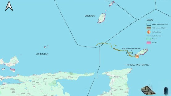
Oil-like substance to spread from T&T into Grenada’s marine area
According to the latest satellite imagery by Copernicus Sentinel-1A, there is the possibility that oil can pass from T&T’s marine area to Grenada’s marine area.
16th of February 2024

Port of Spain, Trinidad and Tobago: The oil-like substance is likely to spread into Grenada’s southernmost marine area. According to the latest satellite imagery by Copernicus Sentinel-1A, there is the possibility that oil can pass from T&T’s marine area to Grenada’s marine area.
As per TTWC and the Tobago Emergency Management Agency (TEMA), the vessel named ‘Gulfstream’ contained a thick black-like substance believed to be oil. The ship measured 78 nautical miles, approximately 144 kilometers in length, and it was extended from West to northwest of Tobago into the Caribbean Sea.
The vessel is believed to be an oil products tanker, and the authorities are working to get rid of the situation. Efforts are being made to contain the spread of the oil.

According to the data, the oil initially covered the windward coastline of Tobago and spread into the ocean from February 6 to 7. On February 11, the oil advanced to 88 kilometres in the West and northwest of Tobago.
It is to be noted that a high-resolution satellite detected that the oil could pass 63 nautical miles or 118 kilometres to the west-northwest on Wednesday. Moreover, it has now reached 30 kilometres out of Trinidad and Tobago’s Economic Exclusive Zone (EEZ).
Noting this, it is one of the seas in which T&T has exclusive rights regarding the exploration and use of marine resources, including energy production from wind and water.
The potential oil slick now extends about 30 kilometres into the southernmost area of Grenada’s Economic Exclusive Zone.
According to TEMA, winds during the satellite image measured 14 knots from the east, which guides the likely path of the potential oil spill.
Based on the current route of a potential oil spill due to prevailing winds and ocean currents, Grenada’s coastline is not in any danger. During this time, no oil/oil-like substances have formed on Tobago’s western or northern coastlines.
Additionally, Prime Minister Keith Rowley is set to seek foreign support if the problem of the oil spill worsens during the media conference last week. He also spearheaded a ministerial team to tour the disaster areas in the Tobago impacted by the oil spill.
Latest
- Guyana’s Linden to Mabura Road Project Nears Completion, Connecting Country to Northern Brazil
-
Trinidad: Unidentified man found dead on Uriah Butler Highway in suspected hit-and-run -
Tuberculosis cases reported at Edward P. Yorke High School in Belize City -
Sugar Mas Carnival boosts St Kitts and Nevis economy to $29.5m -
Jamaican Designer Rachel Scott Debuts Fall 2026 Diotima Collection at New York Fashion Week
Related Articles

7th of December 2024

7th of December 2024

2nd of September 2024

26th of February 2024

13th of February 2024

1st of February 2024

29th of April 2023

