Antigua and Barbuda tracks two Tropical Waves in Atlantic
Antigua and Barbuda is monitoring two tropical waves in the Eastern Atlantic as forecasters assess their chances of development and possible movement towards the Caribbean.
14th of August 2026
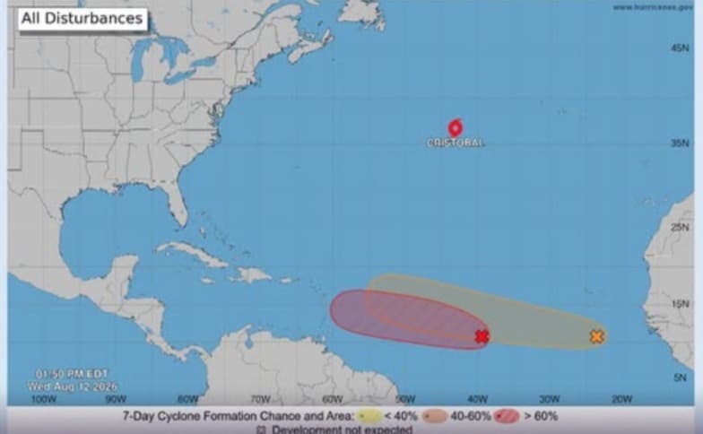
Antigua & Barbuda: The Meteorological Service of the country is currently tracking two tropical waves in the Eastern Atlantic, which could affect the Caribbean in the upcoming days.
The area named AL92 has an 80% chance of formation through 48 hours and an equal chance of development through next week.
An area of showers and thunderstorms linked to one of the tropical waves is located about 950 miles west-southwest of the Cabo Verde Islands, according to the National Hurricane Centre.
Forecasters said environmental conditions are expected to remain favourable for development during the next several days. The system is expected to move westward to west-northwestward across the central tropical Atlantic, with a tropical depression likely to form.
Another tropical wave which is located several hundred miles south of the Cabo Verde Islands which is also producing disorganised showers and thunderstorms is also being monitored by the forecaster.
Conducive environmental conditions have been predicted by the forecasters during the next several days.
The peak period of the National Hurricane Season is nearing from late August into early September. Most Atlantic tropical cyclone activity takes place between mid-August and mid-October.
As per the 1991-2020 climate period an average Atlantic hurricane season has 14 storms, seven hurricanes and three major hurricanes. These figures are long-term averages and do not represent the forecast for the 2026 season.
A tropical wave also developed into Hurricane Erin during the same period last year. According to the National Hurricane Centre, Erin originated from a tropical wave that moved off the west coast of Africa on August 8, 2025. It became a tropical depression and then a tropical storm on August 11 after moving towards the Cabo Verde Islands.
On August 12, 2025, Erin was moving westward across the central tropical Atlantic and was forecast to become a hurricane.
The development of the two systems being monitored by the Meteorological service have not been described as hurricane or tropical storms.
Latest
- Guyana: Businessman shoots suspected robber during Eccles robbery, Police investigate
-
Trinidad and Tobago proposes $23 Million budget increase for National Carnival Committee in 2027 -
Caribbean nations lead global CBI Index 2026 rankings -
Montserrat Festival 2026 Calendar Unveiled, With Events Running From December 4 to January 1 -
Reports claim Christopher “Dudus” Coke fought Sean “Diddy” Combs in US Prison
Related Articles

21st of August 2024

25th of October 2023

13th of July 2022
![After the long wait, over 100,000 doses of Sinopharm coronavirus vaccine reached Trinidad and Tobago on Caribbean airlines Wednesday morning. Minister of Health and Wellness Dr Terrance Deyalsingh went to receive the vaccines that arrived in the early hours of Wednesday. The doses are donated by the People’s Republic of China to help Trinidad and […]](https://content.writeups24.com/production/media/972/187945882_10165450301700472_8631328938177430915_n.jpg "After the long wait, over 100,000 doses of Sinopharm coronavirus vaccine reached Trinidad and Tobago on Caribbean airlines Wednesday morning. Minister of Health and Wellness Dr Terrance Deyalsingh went to receive the vaccines that arrived in the early hours of Wednesday. The doses are donated by the People’s Republic of China to help Trinidad and […]")

14th of April 2021

22nd of March 2021